Hike Petroglyph Canyon via Mouse’s Tank Trail in Valley of Fire
Disclosure: This post contains affiliate links. If you make a purchase through these links, I may earn a small commission at no additional cost to you. I only recommend products or services that I believe will add value to my readers.
Valley of Fire State Park in Southern Nevada is a recreational paradise and escape from the noise and chaos of the Las Vegas Strip. In fact, it’s only a one hour drive (or less) from Vegas!
The park is chock-full of shorter hikes, giving families with small children and those who’re less experienced a chance to witness epic landscapes, mind-boggling geology, and a serene environment.
One such hike is Petroglyph Canyon via Mouse’s Tank Trail. It’s less than a mile (0.7 mile, to be exact) roundtrip along relatively flat and sandy ground through a canyon dotted with hundreds of ancient petroglyphs.
What are petroglyphs, you ask? Petroglyphs are images created by carving, etching, or scraping designs into rock surfaces. This form of rock art is often associated with Native American tribes. Which is the case here.
The petroglyphs in this canyon, much like at nearby Atlatl Rock, are believed to be between 2,000 and 4,000 years old and are associated with the Basketmaker and Early Pueblo cultures.
So what can you expect on this hike? Where in the park is it located? Is it worth it? I answer all of these questions and more in the post below. Let’s get into it!
At A Glance…
Location: Valley of Fire State Park
Fee: Standard park day-use fee
Open: Year-round
For: Hikers and families
Cell Service: None
Restroom: At the trailhead
Parking: Large gravel/dirt lot
EV Stations: None
Difficulty: Easy
Popularity: Moderate
Trail Condition: Easy to follow / soft sand
Stoller Friendly: No
Kid Friendly: Yes
Mileage: 0.7 mile, out and back
Features: Ancient petroglyphs, visually striking rock formations, and natural water basin
Best Viewed: Spring and fall months
Pets: Allowed on leash
Drones: Prohibited
Hazards: Sun exposure and extreme heat (especially in the summer months), potential wildlife encounters
My Visit(s): August 2023 and November 2024
Petroglyph Canyon Trailhead and Parking
The parking lot and trailhead for Mouse’s Tank Trail is located just off of the park’s infamous Mouse’s Tank Road. To get there, you’ll need to drive through either the west or east entrance on the Valley of Fire Scenic Byway and make your way to the visitor center.
Once there, continue up Mouse’s Tank Road for just over a mile, at which point the parking lot for Mouse’s Tank Trail will be on your right. The parking lot is of the dirt/gravel variety and is rather large. There are restrooms here.
The official trailhead is just to the left of the restroom. Keep in mind that while this trail is open year-round, the extreme heat of the summer at Valley of Fire can make this otherwise easy hike a potentially dangerous one.
If you are here in the summer, it might be a good idea to do this one in the morning or later in the evening, as the canyon walls provide a decent amount of shade from the sun at these times.
Petroglyph Canyon
The trail begins via a short descent into the mouth of the canyon on a paved ramp. At the end said ramp, you’ll be hiking on soft sand, which will continue throughout the remainder of your hike.
After a short distance, you’ll soon be surrounded by those reddish/orange rock canyon walls Valley of Fire is famous for. There isn’t much in the way of trees or greenery, just the usual desert brush.
The petroglyphs start popping up almost immediately. There are no signs pointing the way and they’re fairly easy to miss if you’re not paying attention. That said, they’re literally all over the canyon walls.
The first set of petroglyphs I spotted were just a few minutes into the hike. When you come to the sign in the photo above, look for an unmarked path on your left (right about where my Dad is standing in the photo).
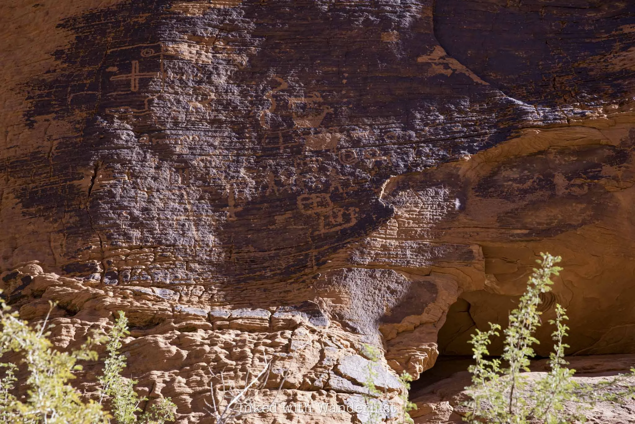
Facing that unmarked path, you’ll notice a large rock in front of you and on the left side of that rock you’ll notice what looks like a large burn mark. That’s actually patina and in that patina is where you’ll find petroglyphs.
This is the largest concentration of petroglyphs on one rock that I’ve seen on this trail. The patina-heavy area of the rock is literally covered in them. I wasn’t able to spot any more in the area, but that doesn’t mean they’re not there.
Continue down the trail and keep your eyes peeled for patina on the canyon walls. Whenever you see patina, there will likely be petroglyphs there. However, there are some on non-patina’d rocks as well, so look out for those.
Before long, you’ll come upon a sign stacked onto a pile of stones pointing left, indicating the end of the trail. Turn left here and walk for about 100 feet to a natural basin of water, otherwise known as the “Mouse Tank”.
The “Mouse Tank” is a natural feature in the rocks that collects water after rainfall. It forms a natural basin where water collects. There are a few of these in the park, but this one is named for an Indian outlaw who hid out in this area named, Little Mouse (more on him momentarily).
Walk down to the end of the trail to view the tank. There isn’t always water in it, and sometimes you’ll need to lean over a fair amount to see it. Watch your footing, as it wouldn’t be fun to fall into that…water or not.
In addition to the water tank, there are more petroglyphs in this area. Some are high up on the rocks, so they’ll be a bit difficult to see. There are plenty others at eye level as well, though.
Throughout this post, you may have been wondering why they named this trail “Mouse’s Tank”. It’s named for a Southern Paiute Indian outlaw by the name of “Little Mouse” who hid in this area after being accused of and wanted for a number of crimes.
The Story of Little Mouse - A Southern Indian Paiute Outlaw
It’s said that Little Mouse - or simply, Mouse - hid in this area of the park after being implicated in the murders of two white prospectors (among other crimes). A posse gathered to find him, but they weren’t as familiar with the area as he was.
Walking through Petroglyph Canyon reveals many potential hiding spots in the walls. Whether or not Little Mouse used any of these spots is up for debate, but the sheer possibility is fascinating.
Little Mouse managed to successfully evade capture by hiding in this canyon for several years, utilizing the tank at the end of the canyon as a water source. How exactly he did that without falling is beyond me.
The posse did end up catching up to Little Mouse, though several miles away from this location near the Muddy River. He was surrounded and killed by the posse. Little Mouse’s guilt of the murder of those prospectors was never fully proven.
I hope this post inspired you to hike Mouse’s Tank Trail and explore all of the petroglyphs. When you’re done here, there are many other hiking trails nearby I recommend. White Domes Loop, Fire Wave and Elephant Rock, just to name a few.
Additionally, you can read this post to see a full list of 10 short hikes in Valley of Fire that I recommend. Additionally, if you have extra days and want to see more petroglyphs, check out nearby Atlatl Rock and the historic Petroglyph Wall in Red Rock Canyon.


