Hiking To Cascade Falls In South Lake Tahoe
5 minute read | contains affiliate links
Cascade Falls is a beautiful series of waterfalls just outside the boundaries of Emerald Bay State Park in Lake Tahoe.
To get the full experience, you’ll need to see it in spring or early summer. Unfortunately, when we came, it was early August. So the run-off was lite.
However, the lack of run-off created dozens of tiny waterfalls scattered throughout (instead of one big cascading waterfall). So it was still a great experience.
In this guide, we’re going to cover all the information you’ll need to visit it for yourself. Topics such as directions, parking information, what to expect and more will be covered.
Let’s get into it.
Quick Stats
Location: West side of Lake Tahoe
Fee/Permit: $10 per vehicle parking fee
Open: Year round, but difficult to access in winter
For: Hikers
Parking: Semi-large parking area
Restroom: In the parking lot
EV Stations: None
Drone Use: Not allowed
Difficulty: Easy to moderate
Popularity: High
Time: 2-3 hours
Milage: 2-miles, round trip
Elevation Gain: 255-feet
Trail Condition: Maintained, but very rocky
Main Feature(s): Cascading waterfall / views of the lake
Pets: Allowed on leash
Special Notes/Hazards: Trail is very rocky. Broken ankles aren’t uncommon on this trail
Our Visit(s): August 2022
Directions, Parking & Trailhead
Getting to the trailhead for Cascade Falls is easy and straight forward. Simply plug Bayview Campground into your GPS and follow the directions.
Shortly after entering Emerald Bay State Park, you’ll see a sign for Bayview Campground on the side of the road. Turn into this lot.
If there’s space available, a parking attendant will approach you to collect the parking fee. It is $10 per vehicle, payable by cash or check.
*Note: Credit/debit cards are not accepted as of 2022
Bayview is a former campground that was re-purposed into a parking for this popular trail. The former camp sites have been repurposed into parking spaces.
If there isn’t space available, you’ll be directed to find a spot along the side of the road. While you won’t have to pay for a spot here, you may have to circle around a couple times and it will add another half-mile to your overall hike.
Cascade Falls Trail
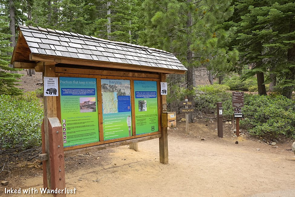
The trailhead is located at the back-end of the parking lot, across from the restrooms. This trailhead is also for the trail to Granite Lake and Maggie’s Peaks.
If you’re only going to Cascade Falls, a Desolation Wilderness permit isn’t required. If you’re going to Granite Lake or Maggie’s Peaks, then you will need to fill one out.
To go to Cascade Falls, head left at the trailhead. This section of the trail takes you under a plethora of shade from the pine trees and is relatively flat.
As you approach Cascade Lake, you’ll hit your first set of steps along this trail. At the top, you’ll get a partial view of Cascade Lake on your left. Keep going to get the full view.
As you reach the top, you’ll continue to follow the dirt/rock trail for another third-of-a-mile. Cascade Lake will remain on your left throughout its entirety.
As you get closer to Cascade Falls, you’ll see a small sign of an arrow pointing left posted on a tree. Heed these directions.
From here, the trail moves over solid granite rock and can be hard to follow. Simply use common sense and head in the direction of the waterfall.
Cascade Falls
As stated earlier in this post, if you’re here in spring or very early summer, you’ll be fortunate enough to experience the falls at peak flow.
We were here in early August, so the run-off was down to a trickle. If you happen to be here during this timeframe, fret not, you’ll be treated to dozens of mini waterfalls.
The best ones we found were closer to the bottom where the edge of the falls is, but there are others literally all over the place. You just have to find them.
If you’re a photographer (or aspiring one) be sure to bring a tripod and ND filter with you to help you get creative with your photos.
To get to the edge of Cascade Falls, you’ll need to scramble down some boulders but don’t worry, it’s nothing difficult.
From there, you’ll have a commanding view of Cascade Lake with Tahoe out in the distance. We’re not certain how accessible this spot is during peak flow, though.
From here, you can continue further up the trail to other desolation lakes. Keep in mind, though, that if you intend to do so you’ll need to have had filled out the permit at the trailhead.
If you’ve gotten your fill, simply head back in the same direction you came. You’ll be on an incline on your way out so make sure you’re prepared with plenty of water.
Your Thoughts…
Have you hiked to Cascade Falls before? Were you fortunate enough to see it at peak flow? Let us know in the comments below. We love hearing from our readers!
Please support our website by sharing it with your family and friends.
Thank you for reading.


